BUKHOSI NGQABUTHO KHUMALO
Cartography, Geoinformatics, Demography, Spatial Analysis
Portfolio
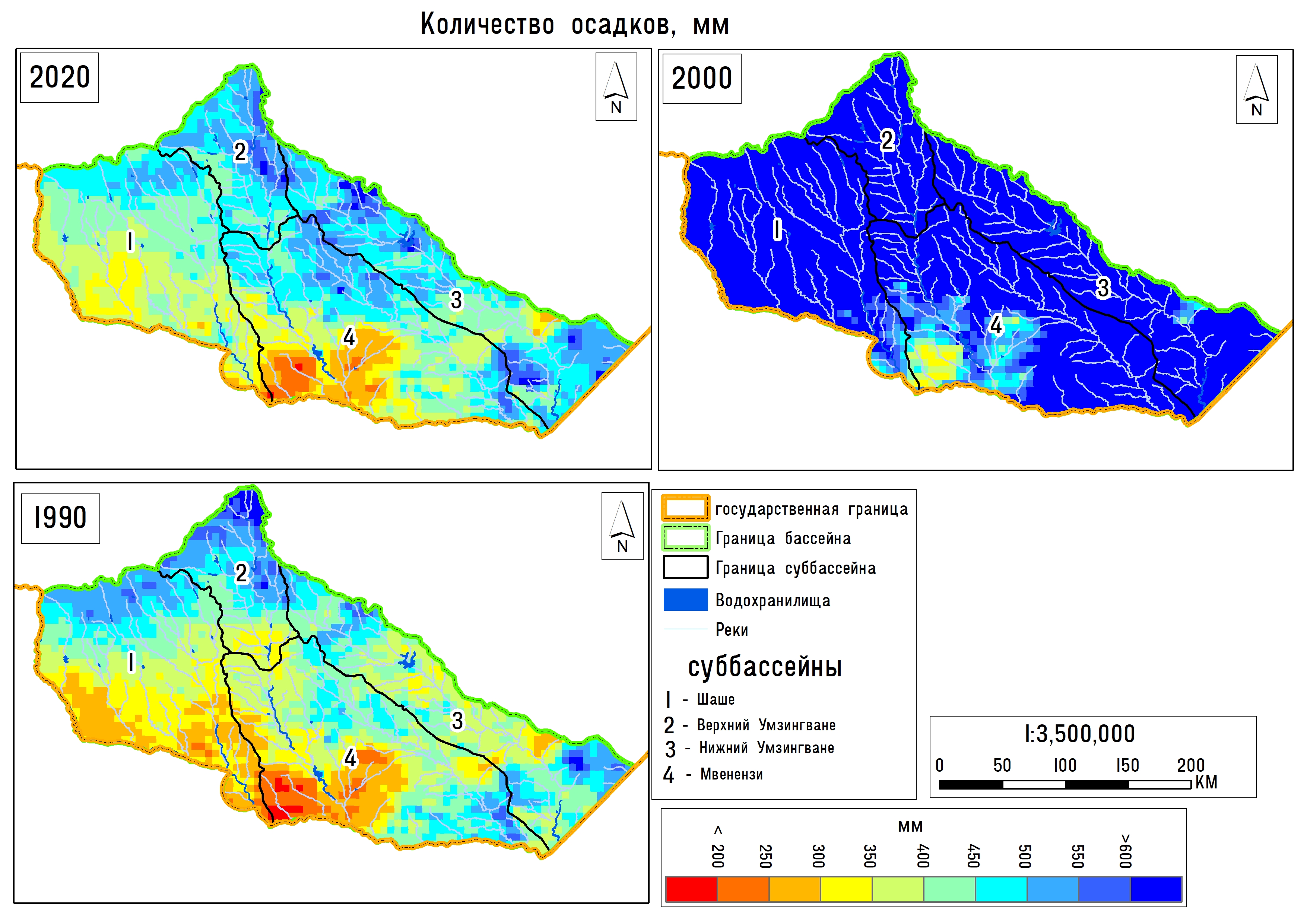
Cartographic and mathematic modelling of the human-nature nexus using geoinformation technologies
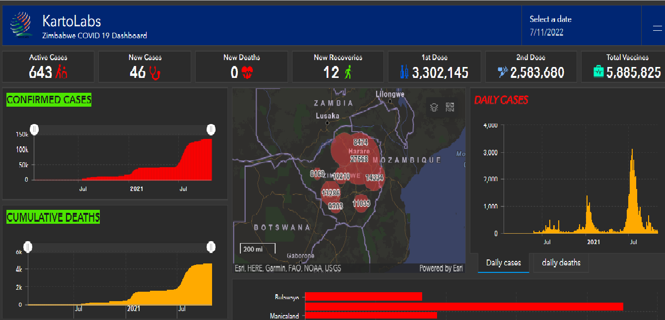
Zimbabwe COVID 19 Dashboard

Zimbabwe Power Supply Dashboard
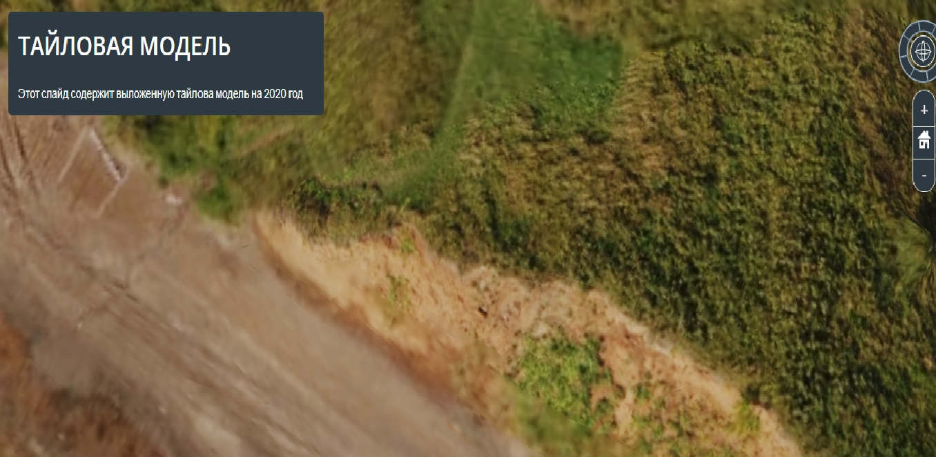
TILE MODEL | Cesium
Maps
Tutorials
About Me

I am a passionate GIS specialist, cartographer, spatial data analyst, and GIS lecturer with a keen interest in using remote sensing, convolutional deep neural networks, and other machine learning algorithms to understand the dynamics of dryland landscapes. With a diverse skill set and a wealth of experience, I strive to leverage geospatial technologies to make informed decisions and drive positive change in the field of environmental management.
GIS and Spatial Analysis:My expertise lies in building dynamic, interactive, and near real-time dashboards using tools such as ArcGIS Online, Tableau, Power BI, and Excel. Through the integration of spatial data and advanced analytics, I have developed insightful visualizations that enable stakeholders to gain a comprehensive understanding of complex geographical patterns and trends. I am well-versed in various GIS software packages, including QGIS, MapInfo, and ArcGIS, allowing me to effectively manage , analyze, and visualize geospatial data
Web Mapping and Development: I possess strong skills in web mapping and development, utilizing OpenLayers and Git to create interactive web maps that provide intuitive access to geospatial information. These maps serve as valuable tools for data exploration, decision-making, and engaging with stakeholders. Additionally, I have experience in Python programming, enabling me to automate workflows and develop custom geospatial applications.
Graphic Design and Data Visualization:To enhance the visual impact of my work, I am proficient in graphic design tools such as Adobe InDesign, Illustrator, Photoshop, and Premiere. I utilize these tools to create visually appealing maps, infographics, and multimedia presentations that effectively communicate complex geospatial information to a wide range of audiences. I strongly believe that powerful data visualization plays a pivotal role in conveying insights and fostering engagement.
Monitoring and Evaluation: In my professional capacity as a monitoring and evaluation officer, I have written manuals on Climate Smart Agriculture and Rangeland Management, providing guidance on best practices and strategies for sustainable land use. I have also prepared comprehensive reports for projects funded by notable organizations such as USAID through Resilient Waters and CNFA, as well as the Global Water Partnership Southern Africa and ASW. My strong analytical skills, combined with my proficiency in statistical software such as SPSS and StatGraphics, enable me to effectively analyze and interpret data to inform evidence-based decision-making.
Continuous Learning and Collaboration: As a GIS lecturer, I have had the privilege of sharing my knowledge and expertise with students, teaching various courses ranging from basic to advanced GIS and remote sensing. I believe in fostering a collaborative and engaging learning environment, encouraging students to explore innovative solutions and apply geospatial technologies to real-world challenges
Contact
Contact me if you are interested in my skills and would like to work with me.